Heritage Monitoring in the Wake of Armed Conflict

Archaeologists and civil society organizations in Armenia face a daunting task in the wake of the ceasefire agreement in Nagorno-Karabakh. Heritage sites are under threat direct threat. Project ArAGATS stands ready to help. In the meantime, The Aragats Foundation has launched a project to compile evidence of heritage destruction posted on social media. If you see something, please tweet it to @aragatsfound so we can follow up.

The Aragats Foundation Teams Up with the HALO Trust

The Aragats Foundation, the non-profit, charitable arm of Project ArAGATS, has joined with the HALO Trust to help with humanitarian relief in Nagorno-Karabakh.

The resumption of hostilities in the region has provoked a massive humanitarian crisis ranging from thousands of displaced persons to unexploded cluster bomb ordinance strewn across cities and villages. We are partnering with HALO to help raise funds to address these urgent needs. So far, we have raised over $10,000, which the Aragats Foundation will match alongside another anonymous donor.

Project ArAGATS: Analysis & Publication

Following the field season in 2018–the 20th anniversary of the project–ArAGATS entered a new phase of materials analysis and publication. Work proceeds on publication of the Kazakh Valley survey, analyses of materials, and the second volume in the ArAGATS monograph series. The latter will provide the full results of our investigations into the Bronze Age on the Tsaghkahovit Plain.

Khatchadourian Examines Armenia’s Contemporary Past

ArAGATS co-director Lori Khatchadourian has initiated a new program focused on the ruins of socialist modernity. She is conducting ethnographic and archaeological fieldwork in decommissioned and underused Soviet factories across Armenia. To learn more, visit the project website and watch the interview with Urbanista below.

Camp Aragats 2018

dsc_3742_3

Camp Aragats, an archaeological camp for girls, kicked off its second season this year. Learning from last year’s pilot program, we expanded the camp to 15 children in order to broaden our impact, and diversified the group by opening it to girls from different towns and villages. Campers from Aparan, Gegharot and Yerevan discovered the science of heritage through hands-on sessions on excavation, architectural drawing, drone flight, ceramic restoration, zooarchaeology, bioarchaeology, paleoethnobotany, and more.

Project ArAGATS 2018

We had another fruitful season on Project ArAGATS this year, with the continued excavation of a semi-circular complex at the Early Bronze Age settlement of Gegharot, and new trenches elsewhere on the western slope that appear to have uncovered segments of a terrace walls and a rectilinear room. Meanwhile the lab team was busy studying human skeletal remains and conducting zooarchaeological and archaeobotanical research. See the Field Season 2018 page for further details.

img_4576_2


Camp Aragats 2017

From July 17-20, the Aragats Foundation organized an archaeological summer camp for young girls from the town of Aparan. The mission of Camp Aragats is to offer children the opportunity to experience archaeology, learn the ancient history of their region, discover the excitement of science and history, and participate in an educational activity during the summer. The pilot project, organized by Lori Khatchadourian and Armine Harutyunyan, was a great success. More photos can be found on the Aragats Foundation’s Facebook page.

group-photo-for-blog

Young visitors

Project ArAGATS always welcomes visitors on site, of all ages. On July 16, an Armenian girl’s camp organized by World Vision stopped by the archaeological site of Aparani Berd, where we’ve been conducting excavations this summer. The children had a crash course in archaeological methods, and learned about the ancient past in their own town.
IMG_3197_2

Kasakh Valley Archaeological Survey (KVAS)

Thunderstorms, hail, lightning strikes, and Soviet land amelioration strategies have not kept the KVAS from achieving some great results already this summer. We are four weeks into the 2016 season and several new sites and finds–from both north and south of our base in Aparan–have come to light.

Kurgan_Cluster

A kurgan cluster recorded this year by the KVAS survey team on the banks of the Kasakh River.

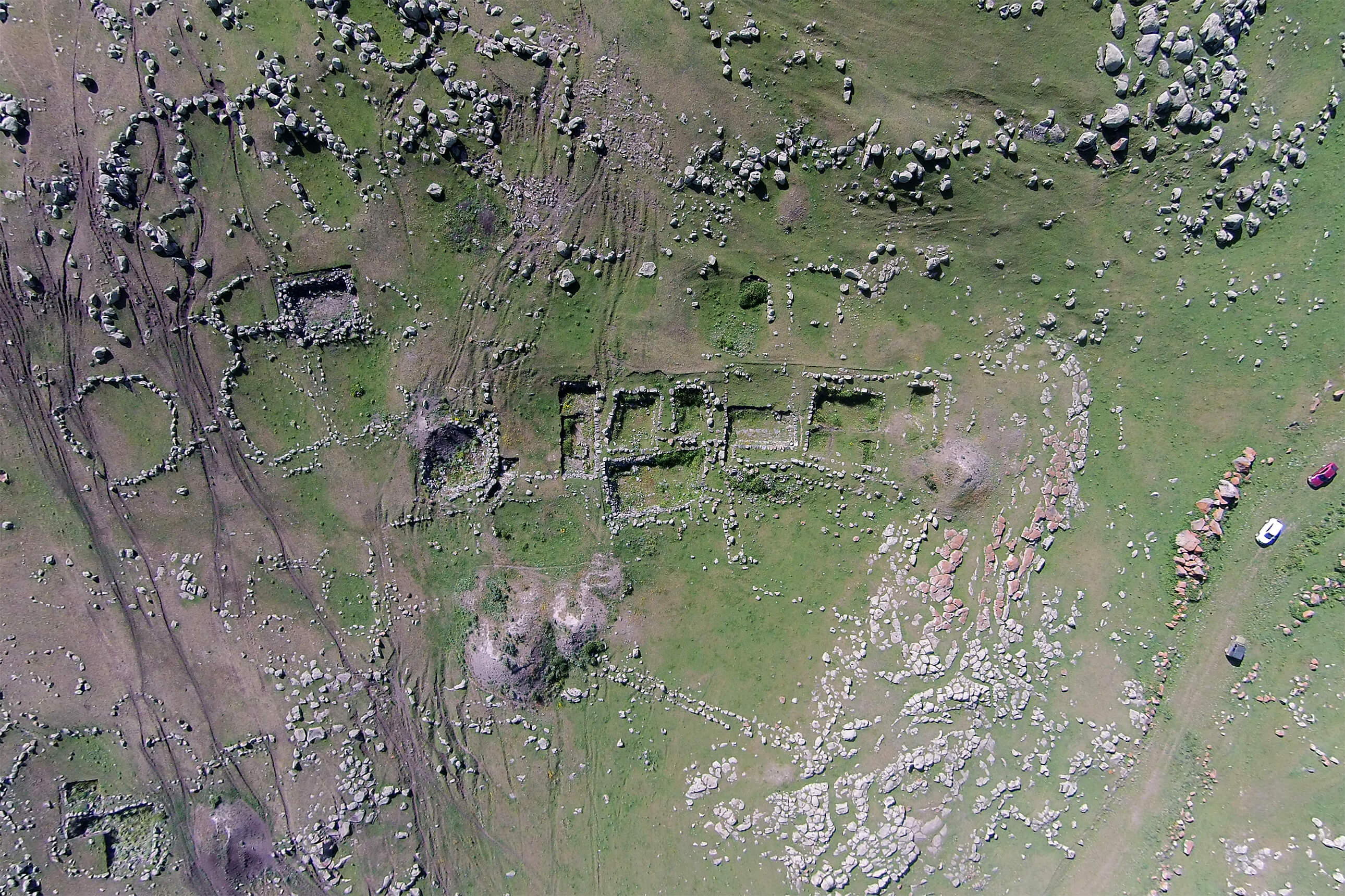
In the upper valley we have recorded a number of intriguing Paleolithic sites, as well as a major kurgan cluster overlooking the Kasakh gorge itself, likely a Bronze Age cemetery. Looking southwards, an Early Bronze Age hilltop site in the vicinity of Vardenut Village connects this landscape to material acquired by the National Museum nearly 100 years ago without exact geographical attribution. Finally, we have also recorded, overlooking Aragats Village at the southern edge of the survey area, and a 4-hectare settlement much closer to Aparan, both of which likely date to the later Medieval era.

Tsaghka_Berd

A fortress provisionally named “Tsaghka Berd” and recorded this year by KVAS high on the slopes of Mt. Aragats. One extant wall over 2 m high is shown in this photo.

Over the second half of the field season we plan to continue our work in the southern portion of the survey area, recording sites on the slopes of Mt. Aragats from Aparan south to the villages of Shenavan and Hartavan. We’ll post more here as the site inventory expands through early August.

Engaged Archaeology: Elementary School Math Night

20150925_193447

Dr. Ian Lindsay (ArAGATS co-director) and a Purdue University colleague assist students with a geocaching game at Cumberland Elementary School’s annual Math Night (West Lafayette, IN).

In an age where assisted navigation systems are available in every new car and standard in our mobile devices, it’s not hard to imaging how the spatial reasoning skills that humans have honed over our long evolutionary history might begin to decline. Indeed the weakening of wayfinding skills is a phenomenon that is being documented in ethnographic cases across the globe, and is part of a broader debate in society about the degree to which modern technology is enhancing human cognition or stunting it (see for example Nicholas Carr’s The Glass Cage [Norton, 2014] vs Clive Thompson’s Smarter Than You Think [Penguin, 2013]). However, even as advanced satellite imagery and navigation technologies help archaeologists document ancient sites with increasing precision and accuracy, map reading and spatial reasoning remain fundamental skills in archaeological fieldwork and analysis. So who better than an archaeologist to instill the value of maps to young people?

With this in mind, I spent an evening at Cumberland Elementary School’s annual Math Night on September 25, using a simple geo-caching game to teach K-3rd graders about the importance and fun of map skills. First, I employed a mock pirate’s treasure map to teach the students about locating places using a set of spatial coordinates (i.e., latitude/longitude). Students were then presented with a map of their school overlaid with a grid and provided with three sets of coordinates that would guide them to secret prizes at each location, usually a classroom. It was an entertaining and rewarding way to enhance applied spatial reasoning and basic math skills relying on kids’ inherent desire to find stuff!

Of course, it didn’t hurt to have Project ArAGATS’ DJI Phantom 3 quadcopter (or, drone) on the table to spark their imagination!