
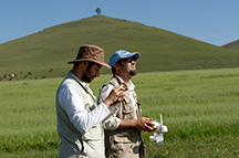
Ian Lindsay and Alan Greene pilot the Project ArAGATS drone.
The use of remotely controlled aerial photography platforms (or more sensationally, “drones”) has received a lot of press in the last few weeks. The New York Times ran a story on the use of drones in archaeology last week focused primarily on work in the Andes. This summer, Project ArAGATS deployed a DJI Phantom 2 to help document sites within our study area in central Armenia.
Cornell has posted a brief note about this work on their tumblr feed. And now Purdue has released a more extensive story profiling our project pilot, Ian Lindsay. In the article, Lindsay notes:
“It’s a good alternative to kites, balloons or sitting in the bucket of a crane with a camera trying to visually document these ancient sites. Drones offer a detailed aerial perspective that we’ve never had before, and by leveraging this technology archaeologists can be more efficient in the field as drones give us an immediate sense of spatial science scale useful for planning excavation.”
The first video project is now posted online on the vimeo feed of The Aragats Foundation and below:
Ancient Aragats: An Orientation from Aragats Foundation on Vimeo.