In 2008, Project ArAGATS celebrated its tenth anniversary by embarking on its most ambitious excavation season to date. We conducted simultaneous excavations at Gegharot, Tsaghkahovit (West Settlement, Burial Cluster 12, and a magnetometric survey of the lower town), and Aragatsiberd. Each of these projects contributed to the Project’s broadly-conceived examination of social and political life in the Tsaghkahovit plain, in the Early Bronze – Iron III periods.
At Gegharot, the research goal was to further explore the articulation of the Early Bronze and Late Bronze periods of occupation on the citadel. The 2006 excavations had uncovered an EB I level of occupation, which had only been evidenced before by ceramics. The 2008 trenches were laid out to examine the relationship between this EB level and the LB levels, and the stratigraphy of the hill. Five new trenches (T21, T22, T23, T24, and T25) were opened in summer 2008, and work also continued in two trenches from the 2006 season, T19 and T20.
Excavations on the east side of the hill illuminated the periodization that had been difficult to read in 2008. We uncovered a large EB room with a clay floor, and at a higher level, a well-preserved LB room with evidence of two periods of building, a clay basin with nine complete vessels in and around it, and a pit with a vast quantity of animal bone and some stone tools. Clay surfaces were found adjacent to (outside of) the LB room, hinting at a possible room complex. On the west side of the citadel, trenches at different elevations on the slope had exposed EB layers at their down-slope sides, with LB still extant and superimposed on EB layers on the up-slope sides, suggesting that erosion could be responsible for the dearth of LB on the western (down-slope) sides of each trench. T21 provided evidence of two distinct periods of LB habitation (including a small shrine, above), as well as an EB layer. In T21, we excavated a large clay basin with a great deal of Late Bronze ceramics, obsidian flakes and tools, and bone.
At Tsaghkahovit, new trenches were put in at the West Settlement (Precinct A) and Burial Cluster 12, and a magnetometer was used to survey the area around the lower town. In Precinct A, we focused on one room in order to advance our ongoing effort to identify social variability among rooms of the complex and to connect previous operations into a single architectural plan. This work is part of a larger research program investigating how communities of the Achaemenid Persian Empire—particularly those of the Armenian highlands—participated in the wider imperial project through their daily material and spatial practices. Column bases, a flagstone floor near a trough or manger, the artifact assemblages, and a wide door leading to an external space suggest the presence of a barn or stable. These findings may indicate that the authorities who utilized the central complex were concerned with direct control of livestock.
Burial Cluster 12 was excavated to better understand Late Bronze Age social and political life, through the investigation of mortuary practices and bioarchaeological analyses of the deceased individuals, and to contextualize the Tsaghkahovit cemetery within the changing burial practices of the 2nd millennium B.C. in the Southern Caucasus. We mapped BC 12 to better compare context, composition, and type of burials within the cluster, which is actually a group of three smaller clusters of cromlech constructions built on the lower slopes of a narrow valley. Six burials were opened, showing differentiation in cromlech construction, artifact assemblage, and in postmortem treatment of the deceased, including evidence of secondary interment and/or excarnation.
The magnetometry survey was designed to investigate the intensity of ancient settlements in the lower town of the Tsaghkahovit fortress as a strategy for targeting future excavations. Surface constructions surrounding all sides of the Tsaghkahovit citadel show an extensive settlement of the site, but prior excavations have also uncovered a domestic complex with no remains on the surface. The survey was therefore employed to investigate the extent of subsurface architecture and related features. Magnetometry provides visual images of subsurface features, recording anomalies in the Earth’s magnetic field, which can then be displayed in GIS software to assist in future relocation and ground-truthing of subsurface deposits.
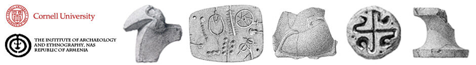
At Aragatsiberd, the research is designed to provide a significant third perspective on the regional patterns in the ceramic economy and the occupation of the Late Bronze Age. In 2008, work resumed in order to understand the periodization of some of the architecture previously revealed, and to uncover the configuration of the north terrace. We opened trenches at different elevations and spaces of the fortress to illuminate the scale and intensity of the LB occupation. This helped to reveal the chronological sequence of the site, and to link it to the same sequences at the Tsaghkahovit and Gegharot fortresses. We found a jewelry mold not dissimilar to those found at Gegharot, demonstrating commonalities of local practice and aesthetics that will aid in the interpretation of sociopolitical organization and authority production within and between the plain’s LB fortresses.